


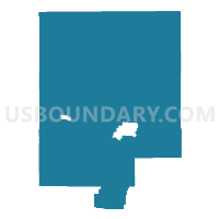
Census Tract 9566, Converse County, Wyoming
About

** Data sources from census 2010 **
Maps


Graphs


Neighbors
Neighoring Census Tract (by Name) Neighboring Census Tract on the Map
- Census Tract 1, Campbell County, WY
- Census Tract 14.01, Natrona County, WY
- Census Tract 18, Natrona County, WY
- Census Tract 9511, Weston County, WY
- Census Tract 9551, Johnson County, WY
- Census Tract 9564, Converse County, WY
- Census Tract 9565, Converse County, WY
- Census Tract 9567, Converse County, WY
- Census Tract 9572, Niobrara County, WY
- Census Tract 9591, Platte County, WY
- Census Tract 9639, Albany County, WY
- Census Tract 9681, Carbon County, WY
Top 10 Neighboring County Subdivision (by Population) Neighboring County Subdivision on the Map
- Gillette South CCD, Campbell County, WY (15,365)
- Casper South CCD, Natrona County, WY (10,489)
- Douglas CCD, Converse County, WY (9,537)
- Newcastle CCD, Weston County, WY (5,696)
- Casper North CCD, Natrona County, WY (5,620)
- Glenrock CCD, Converse County, WY (4,296)
- Hanna CCD, Carbon County, WY (1,639)
- Guernsey CCD, Platte County, WY (1,516)
- West Niobrara CCD, Niobrara County, WY (1,489)
- Kaycee CCD, Johnson County, WY (832)
Top 10 Neighboring Place (by Population) Neighboring Place on the Map
- Douglas city, WY (6,120)
- Glenrock town, WY (2,576)
- Rolling Hills town, WY (440)
- Meadow Acres CDP, WY (198)
- Esterbrook CDP, WY (52)
- Orin CDP, WY (46)
- Lost Springs town, WY (4)
Top 10 Neighboring Unified School District (by Population) Neighboring Unified School District on the Map
- Natrona County School District 1, WY (75,450)
- Campbell County School District 1, WY (46,133)
- Albany County School District 1, WY (36,299)
- Converse County School District 1, WY (9,557)
- Johnson County School District 1, WY (8,569)
- Platte County School District 1, WY (7,251)
- Weston County School District 1, WY (5,687)
- Carbon County School District 2, WY (4,796)
- Converse County School District 2, WY (4,276)
- Niobrara County School District 1, WY (2,520)
Top 10 Neighboring State Legislative District Lower Chamber (by Population) Neighboring State Legislative District Lower Chamber on the Map
- State House District 31, WY (14,418)
- State House District 52, WY (12,056)
- State House District 35, WY (11,445)
- State House District 58, WY (10,860)
- State House District 40, WY (9,987)
- State House District 38, WY (9,702)
- State House District 6, WY (9,518)
- State House District 14, WY (9,049)
- State House District 3, WY (8,892)
- State House District 2, WY (8,224)
Top 10 Neighboring State Legislative District Upper Chamber (by Population) Neighboring State Legislative District Upper Chamber on the Map
- State Senate District 23, WY (26,474)
- State Senate District 30, WY (20,562)
- State Senate District 27, WY (20,320)
- State Senate District 22, WY (19,515)
- State Senate District 2, WY (18,410)
- State Senate District 10, WY (18,279)
- State Senate District 1, WY (17,784)
- State Senate District 3, WY (16,330)
- State Senate District 11, WY (16,180)
Top 10 Neighboring 111th Congressional District (by Population) Neighboring 111th Congressional District on the Map
Top 10 Neighboring 5-Digit ZIP Code Tabulation Area (by Population) Neighboring 5-Digit ZIP Code Tabulation Area on the Map
- 82601, WY (27,400)
- 82604, WY (25,882)
- 82718, WY (23,003)
- 82609, WY (15,730)
- 82633, WY (9,592)
- 82201, WY (6,467)
- 82701, WY (5,455)
- 82637, WY (4,136)
- 82636, WY (3,981)
- 82213, WY (513)